Have you ever looked up at the sky and wondered how those fluffy clouds form or why we experience different weather patterns throughout the year? Well, it’s all connected! In this blog, we’ll explore the fascinating science behind cloud formation and how it ties into weather patterns that affect our daily lives. Whether you’re curious about the next rainfall or why the sky looks a certain way before a storm, we’ll break down everything you need to know in a way that’s easy to understand.
What are Clouds, and How Do They Form?
Clouds are essentially large collections of tiny water droplets or ice crystals that float in the atmosphere. But how do they get there? The process starts with the sun. The sun’s heat causes water from oceans, lakes, rivers, and even plants (through transpiration) to evaporate into water vapour. This invisible vapour rises into the atmosphere because warm air is lighter than cold air.
As the water vapour ascends, it cools down. When it reaches a certain altitude, the air becomes too cold to hold all the moisture. The water vapour then condenses around tiny particles in the air, like dust or pollen. This process is known as condensation, and it’s how clouds begin to form.
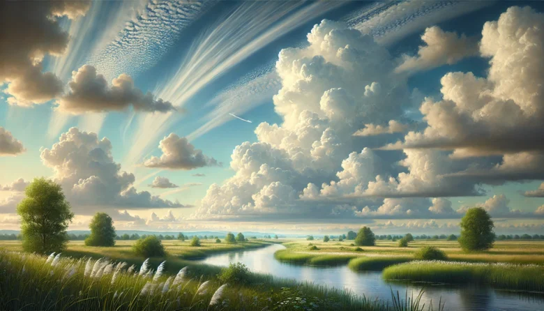
You might be thinking, “But why do some clouds look so different from others?” Great question! Clouds can take on various shapes, sizes, and types depending on factors like temperature, air pressure, and altitude. For example, fluffy cumulus clouds, which often appear on sunny days, form in warmer, rising air. In contrast, thin and wispy cirrus clouds form at higher altitudes where the air is much colder.
The Key Players in Cloud Formation
Clouds don’t just form out of thin air (pun intended). Several atmospheric processes contribute to cloud formation, including:
Evaporation and Transpiration: As mentioned earlier, water from different sources evaporates into the atmosphere, creating a water vapour. Plants also play a role through transpiration, where they release water into the air.
Condensation Nuclei: These are tiny particles like dust, salt, or pollen that provide a surface for water vapour to condense into liquid form. Without these particles, clouds wouldn’t be able to form.
Air Pressure: Low pressure areas often lead to cloud formation because the air rises and cools more quickly. This is why you often see clouds forming in areas of low atmospheric pressure, signaling possible rain or storms.
Temperature: Colder temperatures at higher altitudes help water vapour condense into droplets or ice crystals, forming clouds. The type of cloud depends heavily on how cold or warm the surrounding air is.
Types of Clouds and What They Mean for Weather
Understanding cloud types can actually give you a sneak peek into upcoming weather patterns. Let’s look at a few common types and what they signify:
Cumulus Clouds: These are the iconic puffy clouds you see on clear days. They usually indicate fair weather, though if they grow larger, they can evolve into storm clouds (cumulonimbus).
Stratus Clouds: These low-hanging, blanket-like clouds often cover the entire sky, giving it a gloomy appearance. Stratus clouds are associated with overcast weather and can bring light rain or drizzle.
Cirrus Clouds: These are high-altitude clouds that appear thin and wispy. They usually indicate that a change in the weather is coming, like a warm front or rain in the next day or so.
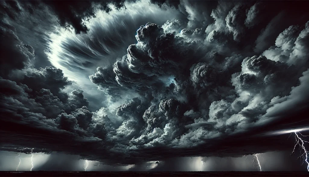
Nimbus Clouds: When you see the term “nimbus,” think rain. Nimbus clouds are rain-bearing clouds, often dark and heavy in appearance. A cumulonimbus cloud, for example, can bring thunderstorms, lightning, and even tornadoes.
How Weather Patterns Are Influenced by Clouds
Clouds do more than just give us picturesque skies; they play a vital role in regulating the Earth’s weather and climate. Clouds can affect temperature by either trapping heat or reflecting sunlight away from the Earth’s surface.
Cooling the Earth: Thick clouds reflect sunlight away, which helps cool the Earth’s surface. This is why cloudy days often feel cooler than sunny days.
Warming the Earth: At night, clouds act like a blanket, trapping heat and preventing it from escaping into space. This is why cloudy nights tend to be warmer compared to clear ones.
Weather patterns are also influenced by the type of cloud cover in an area. For instance, areas with frequent cumulus cloud formation tend to experience more localized thunderstorms, while regions under consistent stratus clouds often have longer periods of drizzle or rain.
Real-Life Example: The Monsoon in India
One of the best examples of how clouds affect weather patterns is the Indian monsoon. During the monsoon season, warm, moist air from the Indian Ocean rises and cools as it moves toward the land. This causes massive cloud formations, particularly cumulonimbus clouds, which then lead to heavy rainfall across much of the Indian subcontinent.
These seasonal changes in cloud formation and weather patterns have a profound impact on agriculture, water supply, and everyday life in India. The presence (or absence) of monsoon clouds can dictate crop success or failure, making cloud formation a key factor in the country’s economy.
The Role of Technology in Weather Prediction
Meteorologists rely heavily on cloud formation to predict weather patterns. Using satellites, radar, and weather balloons, scientists can monitor cloud types, their movements, and how they interact with the atmosphere.
One key tool is Doppler radar, which helps meteorologists track precipitation by bouncing radio waves off clouds. This data is crucial in predicting storms, rainfalls, or even heatwaves. For example, by identifying the growth of cumulonimbus clouds, meteorologists can warn of impending thunderstorms or hurricanes.
Similarly, satellites equipped with thermal imaging can detect high-altitude cirrus clouds that might signal an approaching warm front. By studying cloud movements over time, scientists are better equipped to predict long-term weather patterns, which helps communities prepare for natural disasters.
Conclusion: The Power of Clouds in Shaping Our Weather
Clouds are more than just beautiful formations in the sky. They are key players in the complex system that controls Earth’s weather patterns. By understanding how clouds form and the role they play, we can better anticipate changes in the weather and prepare for what’s to come.
The next time you look up at the sky and see a cloud, remember that it’s part of a vast and intricate process that impacts everything from your local temperature to global climate systems. Keep an eye out for those puffy cumulus clouds or the heavy, rain-laden nimbus formations — they have stories to tell!
Author’s Note
I’ve always been fascinated by the beauty of the natural world, and writing about the science behind everyday phenomena like clouds is a great way to connect with nature on a deeper level. If you have any thoughts, questions, or even cloud stories of your own, feel free to share them!
G.C., Ecosociosphere contributor.
References and Further Reading
- NASA’s Guide to Cloud Formation
- Weather Vocabulary. https://studylib.net/doc/17623291/weather-vocabulary
- Carbon Impacts on Climate Change | Custos. https://www.custoscarbon.com/education/module-carbon-impacts
- How do clouds affect the climate on Earth? | Fox Weather. https://www.foxweather.com/learn/how-clouds-affect-climate-on-earth


Comments
Thank you a lot for sharing this with all folks you really realize what you are speaking approximately! Bookmarked. Please additionally seek advice from my site =). We can have a hyperlink trade contract among us!
Hmm is anyone else encountering problems with the images on this blog loading? I’m trying to find out if its a problem on my end or if it’s the blog. Any feedback would be greatly appreciated.
Terrific work! This is the type of information that should be shared around the internet. Shame on the search engines for not positioning this post higher! Come on over and visit my web site . Thanks =)
I enjoy your writing style really loving this internet site.
Spot on with this write-up, I really assume this web site wants rather more consideration. I’ll in all probability be once more to learn far more, thanks for that info.